If a tsunami were to threaten the San Diego coast, San Diego’s 10 coastal cities and U.S. Naval installations could refer to new tsunami response “playbooks” that include tailored, phased evacuation and mitigation plans for each area.
“Advanced modeling gives us the ability to more accurately predict who may be impacted by an approaching tsunami,” said Holly Crawford, director of the San Diego County Office of Emergency Services (OES). “The playbooks are actionable plans that will reduce the potential for an over-evacuation of communities, which can lead to additional hazards.”
Each community has worked with the County OES and the state to develop evacuation plans based on their topography, inundation zones and populations along the coast.
The California Governor’s Office of Emergency Services and the California Geological Survey announced the revised plans earlier this week as part of Tsunami Preparedness Week.
County OES Senior Emergency Services Coordinator Mike Davis said San Diego is one of five counties chosen to create the tailored playbooks as part of a state pilot program.
Prior to the new playbooks, the tsunami plan was a single, one-size-fits-all response for communities–from those with steep cliffs and no population to those with docked boats, homes or businesses along the water. In San Diego County, emergency managers had one of two choices: clear the beaches only or evacuate the whole region’s tsunami evacuation zone, with its approximately 33,000 homes and businesses.
“These playbooks will allow us to perform more focused evacuations based on the unique characteristics of the impacted areas and more accurate information about the expected tsunami,” said Davis.
Last year, OES mailed tsunami flood surge maps and evacuation routes to the homes and businesses in the tsunami flood surge zone of each of the ten communities.
RELATED: Do You Live in a Tsunami Flood Zone?
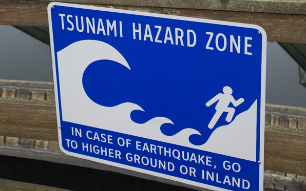
San Diego’s 70 miles of coastline could experience a tsunami caused by a faraway earthquake or one close to shore. If a distant quake caused a tsunami, the federal National Tsunami Warning Center in Alaska would warn local officials of the approaching surge. Since it could take hours to arrive, local officals would have time to refer to the playbook and target evacautions to specific areas.
If a local quake or undersea landslide produced the tsunami, shaking from the quake itself or rapidly receding water might be the only warning signs. In those cases, people in all coastal areas would need to evacuate.
Moving 100 feet above sea level or two miles inland is recommended in San Diego County. Walking may be faster and safer than driving after a quake because of road damage or traffic.
While California overall experienced $100 million in damage to harbors in 2010 and 2011 from the earthquakes in Chile and Japan, San Diego saw minor damage and flooding due to low tides.
The tsunami preparedness strategy will later include maritime response playbooks with harbor planning and guidance for reinforcing harbor structures.
To learn more about tsunami risk, visit TsunamiZone.org.